

Sie folgen nun
Fehler beim Folgen des Nutzers.
Dieser Nutzer erlaubt es nicht, dass andere Nutzer ihm folgen.
Sie folgen diesem Nutzer bereits.
Ihr Mitgliedschaftsplan bietet nur 0 Folgen an. Upgraden Sie hier.
Erfolgreich entfolgt
Fehler beim Nichtfolgen des Nutzers.
Sie haben erfolgreich empfohlen
Fehler beim Empfehlen des Nutzers
Ein Fehler ist aufgetreten. Bitte aktualisieren Sie die Seite und versuchen Sie es erneut.
E-Mail erfolgreich bestätigt.

rawalpindi,
pakistan
Es ist derzeit 11:56 PM hier
Beigetreten am Juli 22, 2020
0
Empfehlungen
Raja K.
@kalaykhan
3,4
3,4
100%
100%
rawalpindi,
pakistan
100 %
Abgeschlossene Arbeiten
100 %
Budgetgerecht
100 %
Pünktlich
25 %
Wiedereinstellungsrate
Geoinformatics Surveyor | BIM Coordinator
Kontaktieren Sie Raja K. bezüglich Ihres Jobs
Melden Sie sich an, um Details im Chat zu besprechen.
Portfolio
Portfolio
VR Panoramic 360 Architectural walkthrough
VR Panoramic 360 Architectural walkthrough
VR Panoramic 360 Architectural walkthrough

VR Panoramic 360 Architectural walkthrough
VR Panoramic 360 Architectural walkthrough


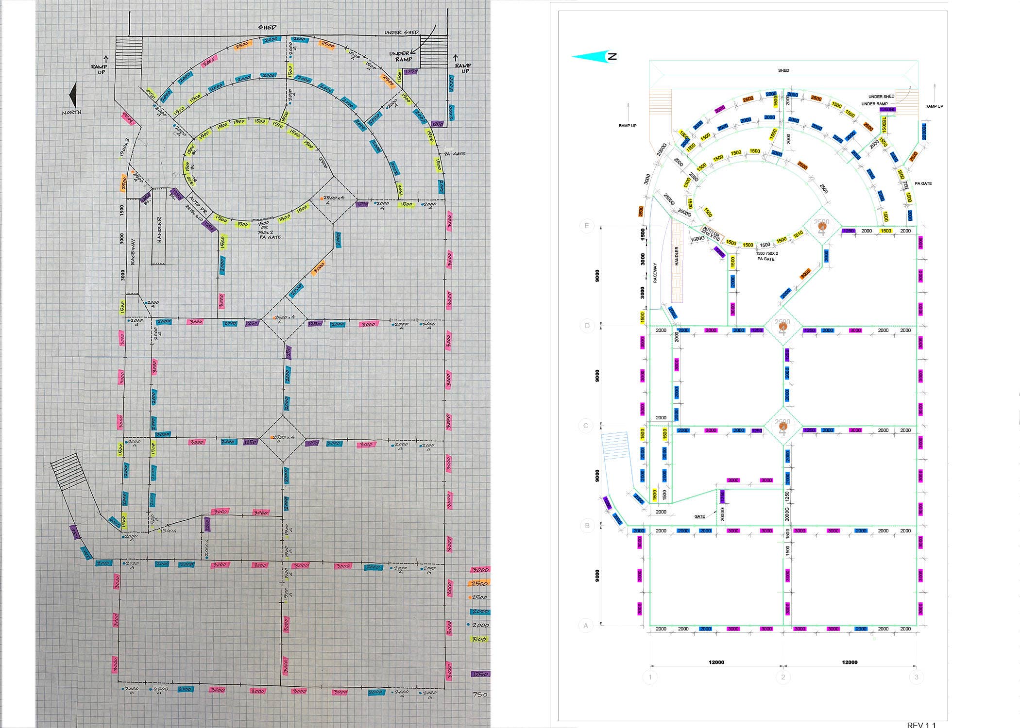
Infrastructural Bridge Modelling in Infra-works 360 BIM

Infrastructural Bridge Modelling in Infra-works 360 BIM

Freehand Sketch to CAD Drawing
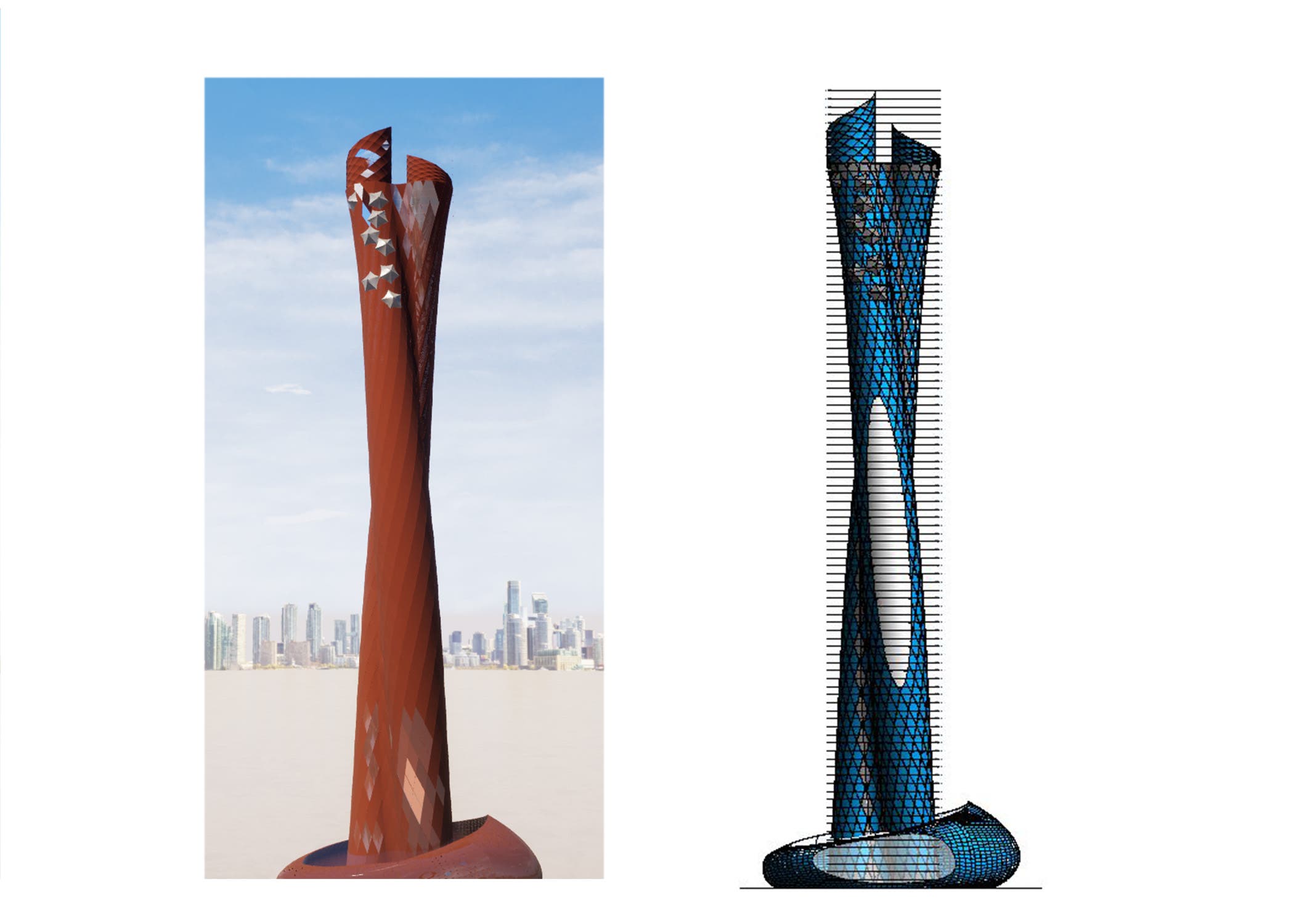

Parametric Dynamo Revit Modelling of Complex Skyscrapers

Parametric Dynamo Revit Modelling of Complex Skyscrapers

Parametric Dynamo Revit Modelling of Complex Skyscrapers
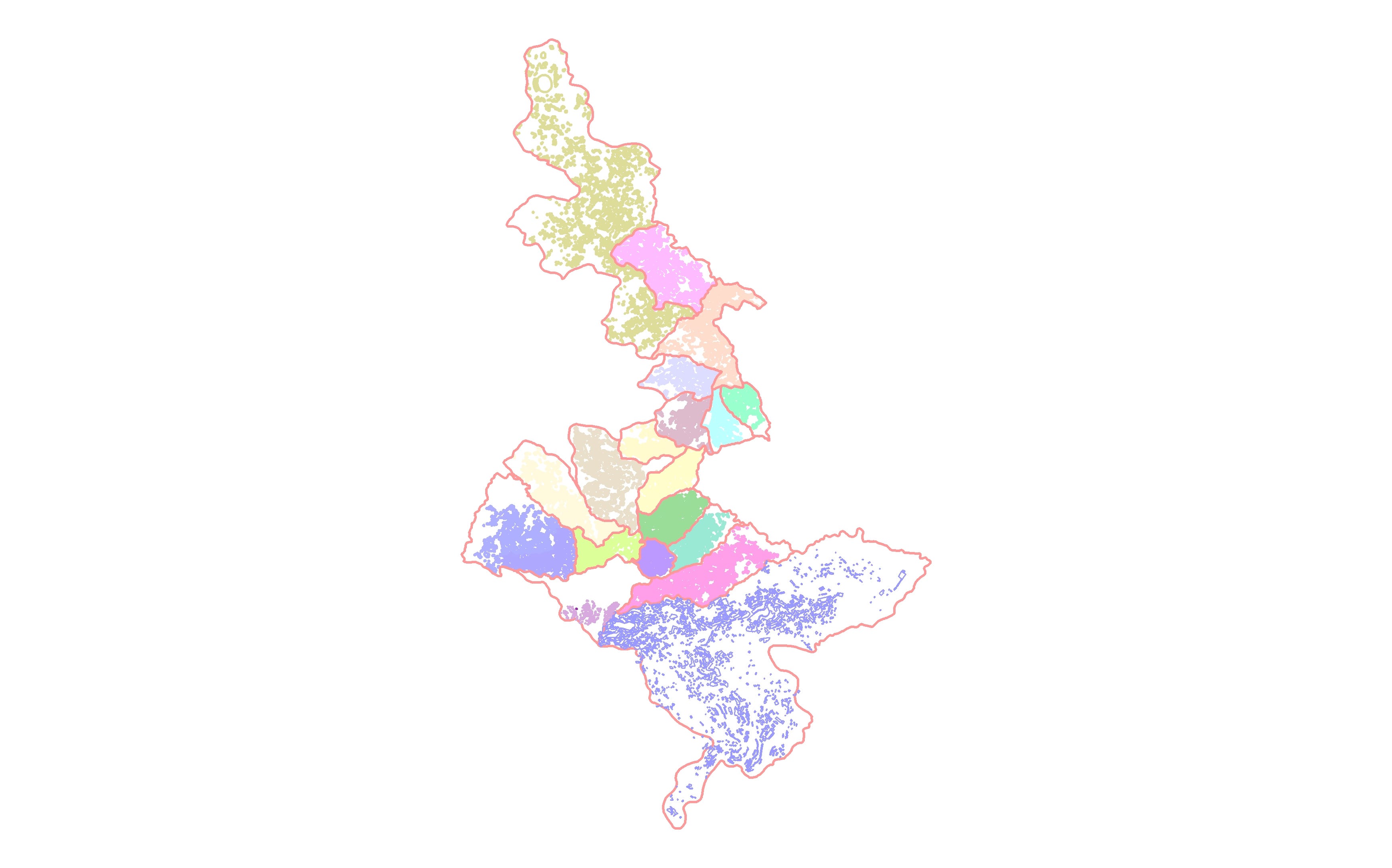

Digitization of 1000 Building Footprints in ArcGIS

Digitization of 1000 Building Footprints in ArcGIS
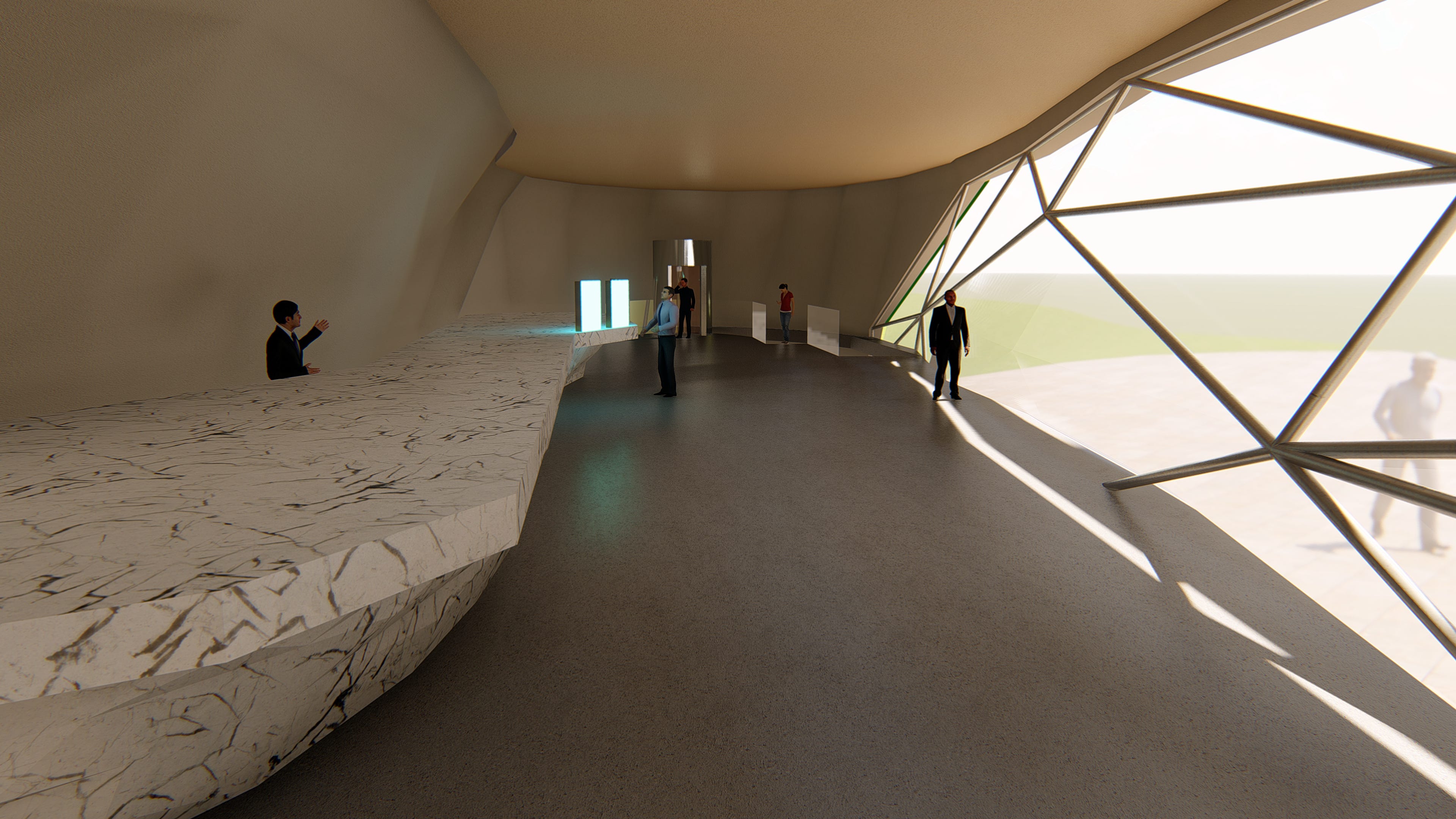

Architectural Interior and Exterior Realistic Rendering

Architectural Interior and Exterior Realistic Rendering
VR Panoramic 360 Architectural walkthrough
VR Panoramic 360 Architectural walkthrough
VR Panoramic 360 Architectural walkthrough
VR Panoramic 360 Architectural walkthrough
VR Panoramic 360 Architectural walkthrough
Infrastructural Bridge Modelling in Infra-works 360 BIM
Infrastructural Bridge Modelling in Infra-works 360 BIM
Freehand Sketch to CAD Drawing
Parametric Dynamo Revit Modelling of Complex Skyscrapers
Parametric Dynamo Revit Modelling of Complex Skyscrapers
Parametric Dynamo Revit Modelling of Complex Skyscrapers
Digitization of 1000 Building Footprints in ArcGIS
Digitization of 1000 Building Footprints in ArcGIS
Architectural Interior and Exterior Realistic Rendering
Architectural Interior and Exterior Realistic Rendering
Bewertungen
Änderungen gespeichert
Zeigt 1 - 2 von 2 Bewertungen
$49,92 USD
Matlab and Mathematica
Cartography & Maps
Geolocation
Mathematics
Geospatial
M

•
$365,00 USD
3D Rendering
AutoCAD
3D Modelling
E

•
Erfahrung
Senior Land Surveyor (Building Information Modelling)
Jan. 2018 - Jan. 2020 (2 Jahre)
1. Preparing Web-Based Online Interactive GIS Maps in Global Mapper and ArcGIS.
2.Coordinates Datum Transformation and Assigning Projected Coordinate System to GIS maps and IFC Drawings.
3.4D 5D Construction Operations Simulations in Bexel Manager.
5.Structural Design Clash Detections Between Existing Details and Proposed Structures in Revit Structural
6.AR/VR Panoramic Rendering of 3D Models for Projects Proposals to ensure Deliverables.
Senior Geomatics Surveyor(Geographical Information System)
Jan. 2017 - Jan. 2018 (1 Jahr)
1.Preparing Road Setting Out Plans (Alignments, Horizontal/Vertical Curves)
2.Excavation Cut/Fill & Earthwork Design Material Quantity Take-off Reports
3.Process Field Survey Data and Prepare As-Built Drawings
4.Consult Technical Support for Equipment’s Calibration.
5.Digital terrain modeling(DTM/DEM) in Surfer and Creating Contour TINNetwork Surfaces.
6.LidarPoint Cloud Data Data Processing and Georeferencing Raster Satellite Imagery in Autodesk Recap
Georeferencing for Stockpiles
Site Surveyor (Structural &Architectural)
Nov. 2014 - Nov. 2017 (3 Jahre)
1.Establishing Control Station Network(Traversing).
2.Coordinate Transformation and Assigning Projected Grid Coordinate System to Shop Drawings.
3.Precise (FFL, SSL & MEP Level) Interpolations, Boundary Demarcation of Property Lines
and Parcels, Document
Controlling (Aconex),
Ausbildung
NCert Land Surveying & Mapping
(2 Jahre)
Qualifikationen
CRICS - Chartered Surveyor
Royal Institute of Chartered Surveyors
2018
CRICS- Royal Institute of Chartered Surveyor - Pathway
PTW -Acceptor / Originator -JO
ADNOC onshore Pipeline Division
2018
Licensed By Abu Dhabi National Oil Company
Associate Surveyor -AS1
Survey of Pakistan
2017
Licensed Professional Associate Land Surveyor
Veröffentlichungen
Does Our Coordinate System Really Exists
Hilal Magazine
Article on Lambert Conic Conformal Map Projection for Kalianpur Zone
Kontaktieren Sie Raja K. bezüglich Ihres Jobs
Melden Sie sich an, um Details im Chat zu besprechen.
Verifizierungen
Zertifikate
Top-Fähigkeiten
Ähnliche Freelancer anschauen
Ähnliche Vorzeigeprojekte ansehen
Einladung erfolgreich zugesendet!
Danke! Wir haben Ihnen per E-Mail einen Link geschickt, über den Sie Ihr kostenloses Guthaben anfordern können.
Beim Senden Ihrer E-Mail ist ein Fehler aufgetreten. Bitte versuchen Sie es erneut.
Das Kopieren in der Zwischenablage ist fehlergeschlagen, bitte nach Anpassung Ihrer Berechtigungen erneut versuchen.
In der Zwischenablage kopiert.
Vorschau wird geladen
Erlaubnis zur Geolokalisierung erteilt.
Ihre Anmeldesitzung ist abgelaufen und Sie wurden abgemeldet. Bitte melden Sie sich erneut an.